Wetlands Wildlife Count in Namibia
In 2007, we flew an aerial survey, requested by the Namibia Nature Foundation, conducting wildlife counts of the wetlands, floodplains and rivers of the Caprivi River system in Namibia, to attain information on the distribution and abundance of wildlife species relative to protected areas and communal conservancies. This season, Sep ’09, we were requested to fly the same survey as a follow-up and compare changes over time. (why conduct aerial surveys? click here)

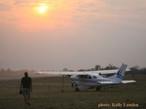
Mornings come early on survey days
Aerial surveys are time consuming and physically tiring, but I actually love participating in them. We wake up before the sun, deprive ourselves of coffee and food, knowing we will be cramped into a small 4-seater Cessna plane, flying at low levels, turning and bumping about, staring at the ground, searching for critters for many hours before landing. We need to fly in the mornings before the sun is too high, while temperatures are cool, mainly for the plane’s sake and fuel consumption, but the cool air certainly helps our comfort levels. We fly until the fuel is almost used up. We land, refuel, pack up the gear, head back to camp, have a bite to eat and then I have the honors of downloading, reviewing and recounting all the wildlife on hundreds of photos to verify the observers’ numbers. If there ever was a penultimate exercise for “eyes”, this would be it! However, I still love the work.
This survey was particularly interesting due to unusually high levels and retention the water system had due to the last rainy season. Namibia’s Caprivi Strip was seriously effected by the highest level the Zambezi river had since 1969: more than 350,000 people lost their livelihoods, more than 55,000 were displaced, and 100 people had lost their lives. (See previous blogs: “Drive along the Boteti”, “Here Comes the Flood”) And the survey’s schedule coincided as huge brush fires in the area were ceasing (see blog “Season of Fires”) I was eager to see not only how many of which animals were where, but also, truly how extensive some of the fires were and how far particular rivers were still flowing and where.

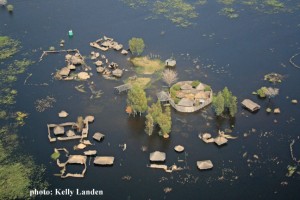
Villages are still underwater in Lake Liambezi
This survey took us 16 days to complete, not counting the subsequent days of photo verification and analysis. We counted almost 20,000 heads of wildlife and in the human-dominated areas or community concessions, we counted almost 32,000 heads of cattle! Some of the observations we made were quite predictable, such as most of the wildlife were found in protected areas and very little was seen in community areas, and of course, the water distribution directly effected wildlife distributions.
Buffalo numbers observed had increased quite a bit
But some of the observations surprised me. First, I was quite relieved to see that most of the large brush fires were completely over and the damage I had expected was not as extensive as some of the previous year’s seasonal fires, well, at least not in the areas we were flying over. Lake Liambezi, which in my years of experience here had only seen it with a minimal amount of water or it so dry that huge, twisting dust storms preoccupied its content, is now a fully functioning large lake again. From the air, we could see huge clumps of Nembwe (species of perch) spawning nests and the surrounding communities set extensive nets taking advantage of their plenty. And we observed a few, very large, wetland birds’ nesting sites, riddled with thousands of nests, which did not exist during the survey in 2007! On the whole, wildlife had increased in numbers by almost 20% since a survey conducted in 2004, but only slightly more than what we observed in 2007. Species such as hippo, lechwe, and crocodile’s numbers were almost the same, but we saw many more buffalo, zebra and impala than the last survey, and surprisingly elephant numbers had increased only slightly. (view more wildlife photos in our gallery, click here)

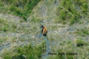
Always exciting to spot a rarely seen Sitatunga
The aerial surveys we conduct are so enlightening, not only on the scientific level, but personal. To witness the seasons’ environmental and wildlife distribution changes first-hand and knowledge-gained are experiences that I hope others can learn from. We must appreciate and remember that the river systems and adjoining community conservancies are valuable habitats for wildlife. Conservation initiatives programs, which promote the wise use of natural resources found in and alongside the river, need to continue to support wildlife and will hopefully encourage increasing wildlife numbers. It is one of the most urgent conservation issues in southern Africa.
To learn more and stay informed, sign on to Elephants Without Borders newsletter… it’s easy! just click here.
Elephants enjoying the cool waters in Namibia's wetlands
Tags: aerial survey count, africa, botswana, conservation, elephants, floods, Namibia, research, wetland, wildlife


