Okavango Panhandle aerial survey 2010
During the last weekend of June, we, EWB, were busy gearing up our equipment, filling up fuel drums to transport into the field, and shopping for supplies to prepare for our second aerial wildlife survey (count) in the Okavango panhandle. (To read why we survey and other surveys conducted, see: http://www.elephantswithoutborders.org/surveys.php)

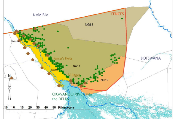
Okavango Panhandle management areas
The Okavango panhandle is a unique area, comprised of 4 wildlife management areas (NG10, 11, 12, 13) enclosed by veterinary fences on the north, east and south and the Okavango river and delta running west. Along the waterfront, the area is dominated by villages with a total population of 17,000 people, agricultural fields, and cattle grazing. Further away from the river is an arid landscape with patches of Mopane, Teak, Acacia and Mongongo woodlands and scattered strips of fossil river beds with natural rain-fed pans. It is a system where wildlife, in particular elephants, and people struggle to live within a confined area.
The purpose of the survey is to answer pertinent questions as to the area’s population of elephants, their growth rate, their limited movements, an insight to human-elephant conflict in the region, and to potentially be able to put forward various management options to relieve elephant compression and their conflict with people. This particular survey is a follow-up, comparative to the first carried out in 2008. We conducted both surveys in collaboration with Anna Songhurst, a Phd candidate, who is looking at human elephant conflict within the region. (see our Collaborations: http://www.elephantswithoutborders.org/collaborations.php)
On Tuesday, the 29th, our team set off to station ourselves at Bumhill camp in the center of Namibia’s Caprivi Strip for the week. The camp is ideally located above the survey area and has a field airstrip just 5km away. With precision timing, Mike Holding, our survey pilot, buzzed us just as we were pulling into camp and we spent the afternoon preparing the plane.
Every morning, as the sun began to rise, our small team of 4, took to the air cramped in a small Cessna plane for 5 hours, flying long transects, only 300 feet above the ground at a speed of 120km/hr, staring intently out the windows in search of elephants and other wildlife. As an observer, calling out the number and species, one only has seconds before the observation quickly passes by. There is only one quick chance for the call-out and if it weren’t for the confidence of having digital photo back-ups taken, sometimes it seemed impossible to be precise!

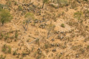
A herd of 50 elephants, difficult to count in a few seconds!
In addition to counting elephants, we documented other species of wildlife, cattle to demonstrate the reaches of their ranges and human related dominance and the locations of elephant bones and carcasses.
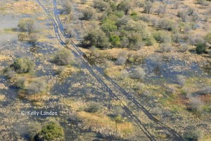
An interesting, influencing factor which determined the locations of elephant herds and other wildlife is the sheer amount of water that is available this season. The pans to the north are still holding water, but more influential is the extreme flood of the Okavango. Villages and fields are flooded, displacing homesteads while the southern reaches of the Northern Buffalo Fence and road to Gudigwa and the Selinda Reserve are completely under water.

Roads and homesteads are flooded
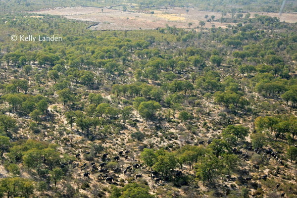
We observed that most wildlife species were found away from human settlements. Virtually no other wildlife species were in close proximity to people, other than a few individual wetland species (hippo, crocodile and lechwe) which were within the floodplains, close to, but inaccessible to people. The pattern was quite similar for elephants, but with some very interesting differences. Elephants were found in concentrations, both breeding herds and bulls near the pans, within some of the woodlands, and in the floodplains furthest away from the villages. There were only a few individual bulls occasionally scattered throughout the concessions. However, the largest concentrations we noted were actually just on the edge of farmer’s fields. Our initial assessment is that the elephants are moving towards the fresh, clean waters of the river, only to be blocked by farmer’s fields and homesteads. They are moving in large numbers possibly for safety. We had several observations every day of elephant bones and elephant carcasses in close proximity to, or within, farmer’s fields. This is not the only place we have seen elephants numbering in the hundreds to thousands close to villages and farms and previously, the scenarios were similar. It is logical to think that “oh, they must be crop-raiding” however, there are no crops at this time of year, only large, empty fields with thicket fences around them.

A large concentration of elephants in close proxiimity to fields
Even from the air, with no crops growing, what does seem obvious though is that human elephant conflict is a disastrous reality that both elephants and people must contend with in the panhandle wildlife management areas. (Read what we are doing about HEC: http://www.elephantswithoutborders.org/living_with_elephants.php)
We hope the information we acquired from these surveys will be key in helping management decisions in the region. We have yet to look at the photos to verify observation callouts of larger numbers, and to analyze the information well before producing the reports and making any recommendations. However, it certainly was an informative and interesting survey.
We want to Thank the Botswana Government for giving us permission to conduct the surveys, our supporters and donors, the San Diego Zoo and Mr. Brett Warren, our support staff of Doo, Themba and Sheke and especially our pilot, Mike Holding for his spot-on flying, keeping us safe and his continuous support to our endeavors.
If you would like to support Elephants Without Borders, it’s easy! Log on to: http://www.elephantswithoutborders.org/donate.php
Tags: aerial survey, africa, botswana, conservation, elephants, elephants without borders, HEC, human-elephant conflict, Okavango delta, research, wetland, wildlife


Very interesting post!